Records smashed with historic category 3 Tropical Cyclone landfall over west coast of Western Australia
April 12 2021:
Tropical Cyclone Seroja made landfall over the west coast of WA near Gregory slightly north of Geraldton just slightly after 7 PM on Sunday as a category 3 tropical cyclone. A record breaking wind gust of 170 km/h was recorded at Kalbarri.It was reported that up to 70% of properties were damaged there.
This was the most intense tropical cyclone landfall that far south along the west coast on record. It is rare for even a category 1 tropical cyclone to make landfall further south along the west coast than that.
Geraldton saw the lowest Mean Sea Level Pressure (MSLP) on record at 976.1 hPa beating the record of 977.3 hPa set on March 14 1979 due to Cyclone Hazel. Geraldton Airport saw the strongest wind gusts associated with a tropical cyclone on record as it reached 120 km/h beating the 117 km/h observed with Cyclone Hazel and 110 km/h observed with Cyclone Alby. Reportedly there were 140 km/h wind gusts in March 1956 and 130 km/h in February 193, though they weren't at the same station.
The Perth Tropical Cyclone Warning Centre (TCWC) estimated a central Mean Sea Level Pressure (MSLP) of the cyclone at 971 hPa at 8 PM local time.
This was the most intense tropical cyclone by 10 minute sustained wind speeds to make landfall over the west coast of WA south of 26° since Severe Tropical Cyclone Hazel in March 1979. Severe Tropical Cyclone Hazel made landfall near Shark Bay Airport as a category 4.
The record strongest tropical cyclone wind gust observed over land south of 26° may have been broken as wind gusts of 170 km/h were recorded at Kalbarri. Tropical Cyclone Marcelle which made landfall over the southwest of the state in May 1973 may have brought stronger wind gusts but the anemometer at Cape Leeuwin then couldn't measure speeds above 130 km/h. Cyclone Alby brought a maximum recorded west coast wind gust of 143 km/h at Fremantle and maximum wind gust recorded over land of 150 km/h at Albany.
Morowa Airport saw the highest wind gust on record of 119 km/h beating the record of 109 km/h set on November 12 2009.
Dalwallinu in the Wheatbelt also saw the highest wind gust on record of 107 km/h beating the record of 106 km/h set on January 29 2011 with Cyclone Bianca.
The BOM says that the last time that Geraldton saw a category 2 impact was in 1956, that cyclone did not make landfall until reaching near Perth.
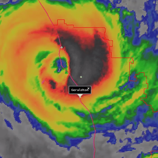
Radar showing the tropical cyclone passing near Geraldton:
Tropical Cyclone Seroja made landfall over the west coast of WA near Gregory slightly north of Geraldton just slightly after 7 PM on Sunday as a category 3 tropical cyclone. A record breaking wind gust of 170 km/h was recorded at Kalbarri.It was reported that up to 70% of properties were damaged there.
This was the most intense tropical cyclone landfall that far south along the west coast on record. It is rare for even a category 1 tropical cyclone to make landfall further south along the west coast than that.
Geraldton saw the lowest Mean Sea Level Pressure (MSLP) on record at 976.1 hPa beating the record of 977.3 hPa set on March 14 1979 due to Cyclone Hazel. Geraldton Airport saw the strongest wind gusts associated with a tropical cyclone on record as it reached 120 km/h beating the 117 km/h observed with Cyclone Hazel and 110 km/h observed with Cyclone Alby. Reportedly there were 140 km/h wind gusts in March 1956 and 130 km/h in February 193, though they weren't at the same station.
The Perth Tropical Cyclone Warning Centre (TCWC) estimated a central Mean Sea Level Pressure (MSLP) of the cyclone at 971 hPa at 8 PM local time.
This was the most intense tropical cyclone by 10 minute sustained wind speeds to make landfall over the west coast of WA south of 26° since Severe Tropical Cyclone Hazel in March 1979. Severe Tropical Cyclone Hazel made landfall near Shark Bay Airport as a category 4.
The record strongest tropical cyclone wind gust observed over land south of 26° may have been broken as wind gusts of 170 km/h were recorded at Kalbarri. Tropical Cyclone Marcelle which made landfall over the southwest of the state in May 1973 may have brought stronger wind gusts but the anemometer at Cape Leeuwin then couldn't measure speeds above 130 km/h. Cyclone Alby brought a maximum recorded west coast wind gust of 143 km/h at Fremantle and maximum wind gust recorded over land of 150 km/h at Albany.
Morowa Airport saw the highest wind gust on record of 119 km/h beating the record of 109 km/h set on November 12 2009.
Dalwallinu in the Wheatbelt also saw the highest wind gust on record of 107 km/h beating the record of 106 km/h set on January 29 2011 with Cyclone Bianca.
The BOM says that the last time that Geraldton saw a category 2 impact was in 1956, that cyclone did not make landfall until reaching near Perth.
Radar showing the tropical cyclone passing near Geraldton:

View radar loop at https://theweatherchaser.com/radar/IDR062/2021-04-11-17/2021-04-11-22/Australia%2FPerth
Satellite loop showing the tropical cyclone making landfall:
Satellite loop showing the tropical cyclone making landfall:

Microwave loop:

False colour infrared loop:


Dvorak loop:

Satellite derived wind shear:

Satellite derived low level wind convergence:

Satellite derived upper level wind convergence:

Satellite derived 850 hPa vorticity:
