Artificial intelligence (AI) beating numerical weather prediction (NWP)
Written by Evanston Tan May 30 2024.

Figure 1. Comparison of model prognosis of 24 hour precipitation in the 24 hours to 12Z May 30 2024 between the 00Z model run on Wednesday May 22 2024 of the ECMWF Artificial Intelligence (AI) based model and the ECMWF physics based Numerical Weather Prediction (NWP) model. Image courtesy of Meteologix.
Once again, the ECMWF Artificial Intelligence (AI) based model had beaten the physics based NWP models hands down 8 days out to today. According to data published by the ECMWF, the AI based model has greater skill than the physics based NWP model especially at longer lead times for 500 hPa height anomaly.
In the 00Z run last Wednesday for example, the ECMWF physics based NWP model predicted mostly dry conditions throughout most of Australia in the 24 hours to 12Z today. The ECMWF Artificial Intelligence (AI) based model model however, predicted a northwest cloud band extending all the way from the tropics through the NT and into Victoria reaching all the way to Tasmania and separately also stream showers for Perth and a maximum activity in shower activity to the south of the Southern Coast of WA.
Fast forward to today, indeed there a northwest cloud band extending all the way from the tropics through the NT and into Victoria reaching all the way to Tasmania and separately also stream showers for Perth and a maximum activity in shower activity to the south of the Esperance Coast and Eucla Coast of WA as the AI model had predicted but the NWP did not. The AI had picked up these features for several consecutive runs before the NWP model did.
ECMWF AI based 00Z run last Wednesday prediction of 24 hour precipitation in the 24 hours to 12Z today showing a northwest cloud band extending all the way from the tropics through the NT and into Victoria reaching all the way to Tasmania and separately also stream showers for Perth and a maximum activity in shower activity to the south of the southern coast of WA:

Figure 2. ECMWF AI based 00Z run last Wednesday prediction of 24 hour precipitation in the 24 hours to 12Z today showing a northwest cloud band extending all the way from the tropics through the NT and into Victoria reaching all the way to Tasmania and separately also stream showers for Perth and a maximum activity in shower activity to the south of the Esperance Coast and Eucla Coast of WA. Image courtesy of Meteologix.
ECMWF Physics based Numerical Weather Prediction (NWP) of the same model run predicted mostly dry conditions throughout most of Australia in the 24 hours to 12Z today:

Figure 3. ECMWF Physics based Numerical Weather Prediction (NWP) of the same model run predicted mostly dry conditions throughout most of Australia in the 24 hours to 12Z today. Image courtesy of Meteologix.
ECMWF NWP 12Z run yesterday prognosis of 24 hour precipitation in the 24 hours to 12Z today, a good enough proxy of actual conditions for this illustration and context (for the time being given that reanalysis data is not yet available) showing that indeed there was a northwest cloud band extending all the way from the tropics through the NT and into Victoria reaching all the way to Tasmania and separately also stream showers for Perth and a maximum activity in shower activity to the south of the southern Coast of WA:

Figure 4. ECMWF NWP 12Z run yesterday prognosis of 24 hour precipitation in the 24 hours to 12Z today, a good enough proxy of actual conditions for this illustration and context (for the time being given that reanalysis data is not yet available) showing that indeed there was a northwest cloud band extending all the way from the tropics through the NT and into Victoria reaching all the way to Tasmania and separately also stream showers for Perth and a maximum activity in shower activity to the south of the Esperance Coast and Eucla Coast of WA. Image courtesy of Meteologix.
ACCESS-G 00Z run last Wednesday Numerical Weather Prediction (NWP) based model 24 hours precipitation to 12Z today:
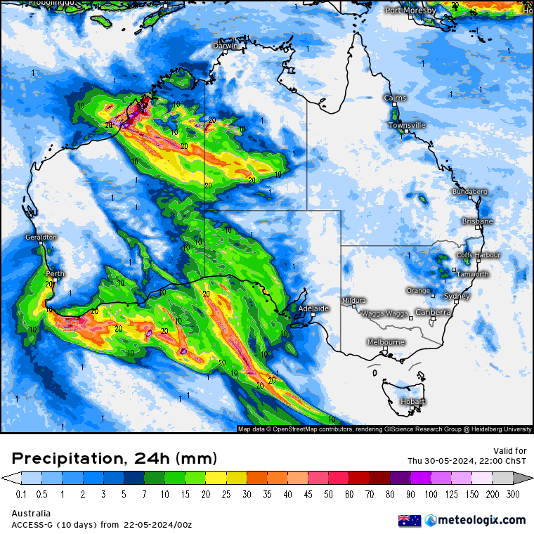
Figure 5. ACCESS-G 00Z run last Wednesday Numerical Weather Prediction (NWP) based model 24 hours precipitation to 12Z today. Image courtesy of Meteologix.
GFS 00Z run last Wednesday Numerical Weather Prediction (NWP) based model 24 hours precipitation to 12Z today:
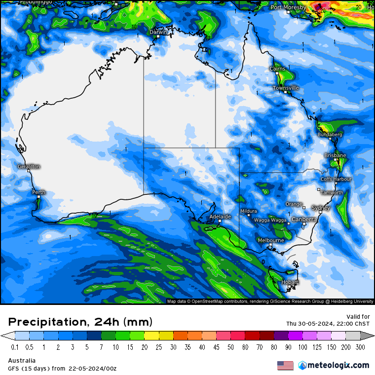
Figure 6. GFS 00Z run last Wednesday Numerical Weather Prediction (NWP) based model 24 hours precipitation to 12Z today. Image courtesy of Meteologix.
GEM 00Z run last Wednesday Numerical Weather Prediction (NWP) based model 24 hours precipitation to 12Z today:

Figure 7. GEM 00Z run last Wednesday Numerical Weather Prediction (NWP) based model 24 hours precipitation to 12Z today. Image courtesy of Meteologix.
The ECMWF Artificial Intelligence (AI) based model has higher skill than the physics based Numerical Weather Prediction (NWP):

Image courtesy of Meteologix.