Artificial Intelligence (AI) beats Numerical Weather Prediction (NWP)
Written by Evanston Tan on May 7 2024.
What I find interesting is that the 24 hour precipitation to 9 AM Monday Sydney forecast that the ECMFWF AIFS (AI) had actually beaten the GFS consistently across multiple model runs. The AI was predicting around 28 mm almost a week out whilst the GFS even the day before was predicting like 10-15 mm of rain. Actually 31.2 mm of rain fell.
I also looked at the MSLP predictions of the AI and physics based ECMWF for the 12Z run of May 1st for 06Z today (May 7). The AI beaten the physics based model hands on.
Physics based ECMWF 12Z May 1st prediction for 06Z today showing the centre of the high pressure to the east of Tasmania in the Tasman Sea and a strong trough near the Western Australia- South Australia border:
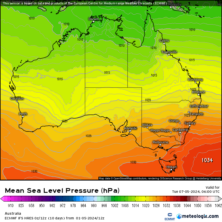
Figure 1. Physics based ECMWF 12Z May 1st prediction for 06Z today showing the centre of the high pressure to the east of Tasmania in the Tasman Sea and a strong trough near the Western Australia- South Australia border. Image courtesy of Meteologix.
AI based ECMWF 12Z May 1st prediction for 06Z today showing the centre of the high pressure in the Great Australian Bight to the southwest of Tasmania and the trough in Western Australia instead being nearer to the west coast:

Figure 2. Artificial Intelligence (AI) based ECMWF 12Z May 1st prediction for 06Z today showing the centre of the high pressure in the Great Australian Bight to the southwest of Tasmania and the trough in Western Australia instead being nearer to the west coast. Image courtesy of Meteologix.

Figure 3. Actual MSLP at 06Z today showing the centre of the high pressure in the Great Australian Bight to the southwest of Tasmania and the trough in Western Australia instead being nearer to the west coast. Image courtesy of the Bureau of Mereology.
Below highlights some subtle features that the AIFS picked up almost a week in advance that the physics based model failed to pickup:
Below that I also show the output of all the physics based models of ECMWF, ACCESS, GFS, ICON, GEM and JMA showing how the AI beats all of them hands down:
Below highlights some subtle features that the AIFS picked up almost a week in advance that the physics based model failed to pickup:
Below that I also show the output of all the physics based models of ECMWF, ACCESS, GFS, ICON, GEM and JMA showing how the AI beats all of them hands down:
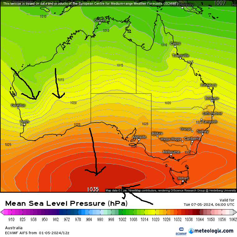
Figure 4. Subtle features that the AIFS picked up almost a week in advance that the physics based model failed to pickup.

Figure 5. The actual MSLP with the subtle features highlighted.
Figure 6. ECMWF Physics based output. Image courtesy of Meteologix and ECMWF.

Figure 7. ACCESS-G output. Image courtesy of Meteologix and the Bureau of Meteorology.

Figure 8. GFS model output. Image courtesy of Meteologix.

Figure 9. GEM Model output. Image courtesy of Meteologix.

Figure 10. ICON model output. Image courtesy of Meteorologix.

Figure 11. UKMO model output. Image courtesy of Meteologix.

Figure 12. JMA model output. Image courtesy of Meteologix.