Trends in fire danger over Australia:
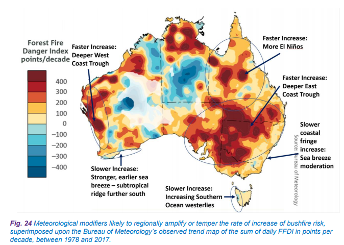
Image courtesy of Insurance Australia Group (IAG).
The following has been submitted by Mark Leplastrier of Insurance Australia Group (IAG) to the Bushfire Royal Commission (Royal Commission into National Natural Disaster Arrangements):
The FFDI data can be combined with known trends in weather systems to produce an initial view of changes to bushfire risk at a regional level. This is illustrated in Fig. 24 and summarised below:
The future climate predictions across Australia from the available science are inconsistent in terms of the measures of fire danger used and how they are likely to change in the future.
Although the maps in Bureau of Meteorology and CSIRO (2016, 2018) serve as a guide, the predictions from Lucas et al. (2007) using the CSIRO MK3 high scenario results for spot locations then applied to the surrounding districts are used as the initial basis for the changing bushfire risk. This is checked against the Sharples et al. (2016) research.
For Tasmania, the work of Fox-Hughes et al. (2015) serves as a general guide to expected trends for the south-east of Australia.
For Perth and the south-west of Western Australia, the Climate Council Report on Western Australian bushfires (Steffan et al. 2015) is used as a guide, adapted to be consistent with the remainder of Australia.
Consideration is also given to the meteorological modifiers likely to be present on the days when there are some of the more extreme bushfire conditions. For the more populated South West Land Division of Western Australia, these include the presence of a deeper west coast trough, which becomes deeper due to the increased heating of the land and amplifies the bushfire risks, and the corresponding increase in the strength of the south coast sea breeze for Western Australia as the sub-tropical ridge shifts southwards with the warming climate, tempering the rate of increase in risk.
For a large part of south-eastern Australia, the warming climate supports a more persistent east coast trough which tends to support longer periods of high bushfire risk conditions. This is slightly tempered on the east coastal margins by the persistent sea breeze effects.
For large parts of Queensland, the trend towards a faster increase in SSTs in the central equatorial Pacific Ocean relative to the Coral Sea produces more El Niño-type weather patterns that support longer hot and dry spells across eastern Australia, conducive to the
repeated occurrence of severe bushfire conditions.
For the west coast of Tasmania, the rate of increase in bushfire risk is tempered by the observed trend of increasing speed of the Southern Ocean westerly winds.
You can read the full document at https://www.iag.com.au/sites/default/files/documents/Severe-weather-in-a-changing-climate-report-011119.pdf .